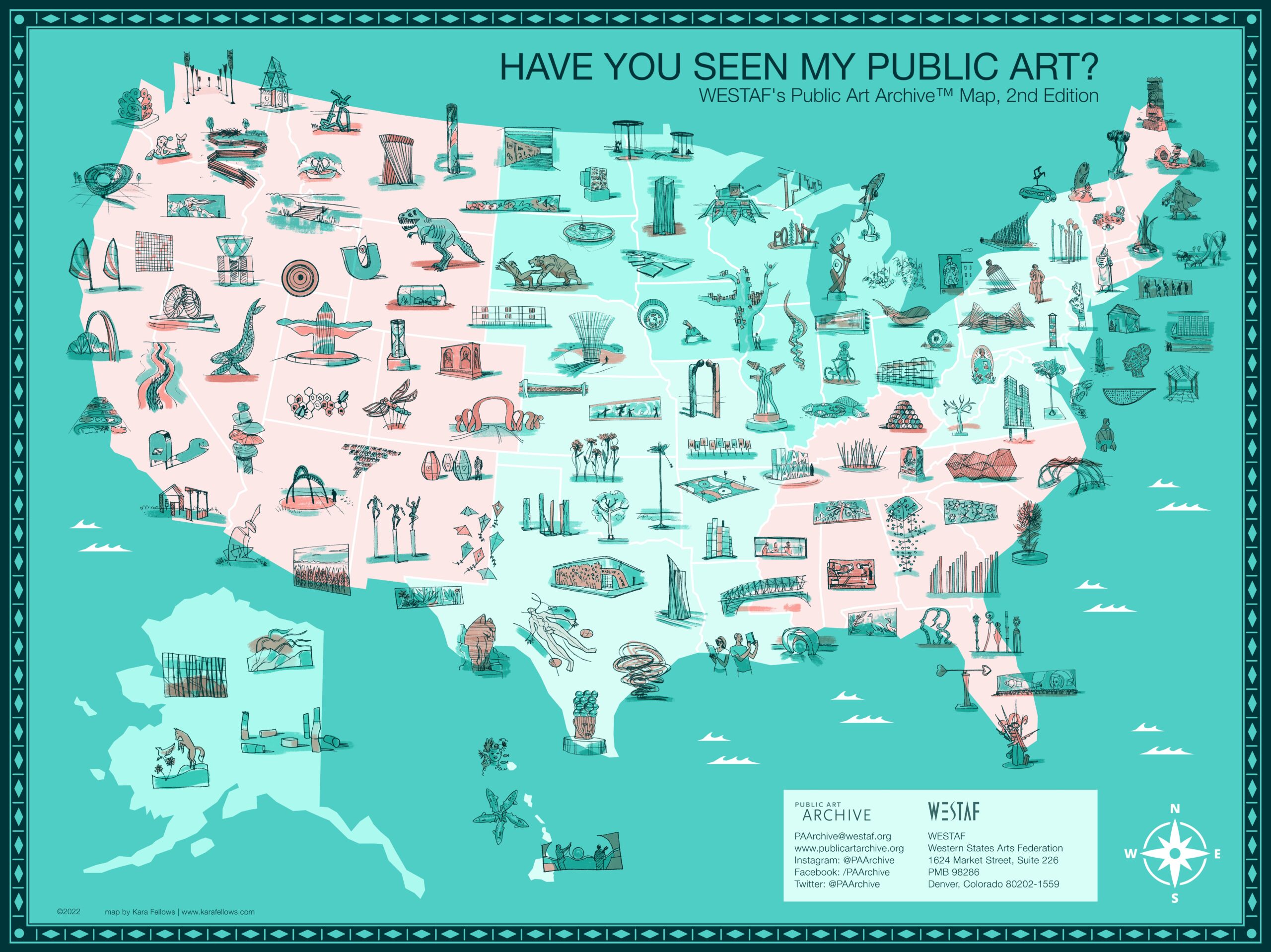
WESTAF’s Public Art Archive Map, 2nd Edition
The Public Art Archive™ (PAA) is thrilled to unveil the second edition of its celebratory Have You Seen My Public Art? Map. The second edition of the map includes 144 artworks across all 50 states created by over 176 unique artists and studios within the last 10 years. Engage with the interactive map below to learn more about the artworks chosen for this project.
+Hover over illustrations to activate the interactive map.


*This map is an illustration. Artworks are not drawn to scale and their placements on the map may not be exact. For accurate information regarding artwork locations, we welcome you to engage with the interactive map to view the individual artwork detail pages.
[social_buttons facebook=”true” linkedin=”true”]
About the Project
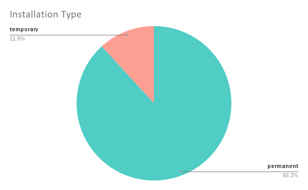
The Public Art Archive™ (PAA) is thrilled to unveil the second edition of its celebratory Have You Seen My Public Art? Map. Ten years have passed since PAA commissioned the first edition, which brought visibility to the program when it originally launched. Since that time, the PAA team has continued its mission to make public art more public by archiving almost 20,000 public artworks around the U.S. (with a growing number of international works) at no cost to both artists who create the artwork and organizations that commission or own the works. PAA continues to be an entirely free resource for documenting public art and discovering art in every community through its digital platforms. Thanks to the amazing work of Boulder-based artist Kara Fellows, who was commissioned to illustrate the selected artworks and design the map. We are extraordinarily proud to share the second edition of Have You Seen My Public Art? as a way to show our gratitude and appreciation for all those collaborators who have contributed to PAA over the years.The second edition of the map includes 144 artworks across all 50 states created by over 176 unique artists and studios, mostly within the last 10 years. Projects vary in type (outdoor sculpture, mural paintings, wall pieces, etc.), placement (universities, parks, municipal buildings, transportation spaces, etc.), media (steel, paint, wood, etc.), theme, and budget and demonstrate a mixture of both permanently-sited and temporarily installed works. Breakdowns and analyses of the artworks chosen for this project, providing a snapshot of trends and patterns in the field over the past decade, can be explored below.
The project received over 500 submissions, and while all of the projects are not included on the map, they have all been cataloged in the PAA database and are available for public exploration and discovery through our desktop site and Locate app. Thank you to all contributors to this project. It is our hope that it will reinvigorate the desire and need for a central repository of public art data so that all members of the public can engage with public art across every community.
The Process
PAA sent out a call to artists and organizations across the country to submit their artworks to a juried competition for a spot on the map. A jury of 12 staff members from diverse departments across WESTAF volunteered to review and rate the submissions. Once the jurors’ scores were analyzed and tabulated, images of the top-rated artworks were passed along to Boulder, Colorado artist Kara Fellows, who created individual hand-drawn illustrations of each of the 144 selected artworks to be featured on the map. While Kara was at work creating the map, the PAA team performed a data analysis of all the selected artworks to reveal insightful trends and patterns. We also added all 500+ submissions to the Public Art Archive so that they can be discovered and enjoyed by our wide-ranging audience. Our sincerest thanks to our jury members, artist Kara Fellows, and everyone who participated in this project and continues to help us make public art more public!
Artwork Analyses
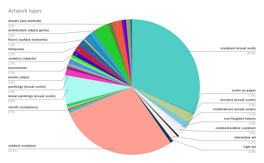
Artwork type refers to the kind of artwork being described. The Getty Art & Architecture Thesaurus provides a robust list of possible categories the Public Art Archive uses to categorize artworks throughout the database. As the field of public art expands, so does this list of artwork types. As evidenced by the data analysis for this project, sculpture (especially outdoor sculpture) and murals are the most prolific types of public art.
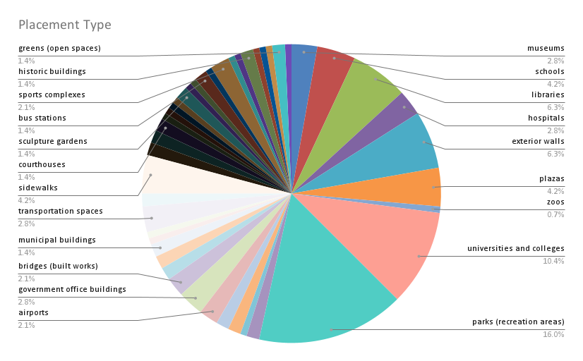
Placement type refers to the many settings in which public art is installed. Placement types can range from public buildings such as city halls and libraries to outdoor spaces accessible by any member of the public, such as sidewalks, parks, and plazas. For this data set, public art was largely located in parks and on university campuses.